Our “Model Community” gets drawn and quartered in the new draft plan…
RON ROSE
In the December issue of The Mainstreeter, Alain Miguelez, the City of Ottawa’s manager of policy planning, praised Old Ottawa East (OOE) as a model community and a demonstration of what the City would consider a planning success. In support of his glowing conclusions, Miguelez cited the intensification around Greystone Village and the infrastructure improvements within OOE that encourage active transportation.
How ironic it is, then, that this model community is being torn apart by the very draft Official Plan it is supposed to personify. Recent planning proposals by Ottawa city planners set out in the draft plan would, if approved by City Council, tear away various parts of our community and allocate them elsewhere for planning purposes. And these proposals have been developed “in the dark”, without any consultation with OOE residents or with Capital Ward Councillor Shawn Menard. To be clear, geographically and socially, the community of Old Ottawa East will continue to exist, but, if these changes in the new Official Plan are implemented, our community’s ability to continue planning for its future development would be rendered far more difficult.
Compounding the harmful impact of these proposals is a recent decision taken by the City Council to carve out the portion of Old Ottawa East lying east of the Lees Avenue LRT line and to transfer planning jurisdiction over the area from Capital Ward to Rideau-Vanier Ward (for more details on this decision, see John Dance’s article).
Community gets divided
The first Official Plan proposal involves the scrapping of the 2011 Secondary Plan for Old Ottawa East and dividing the community going forward between two new Secondary Plans. A Secondary Plan is the City Council-approved planning document that implements the vision of a Community Design Plan and provides guidelines for the development of a community.
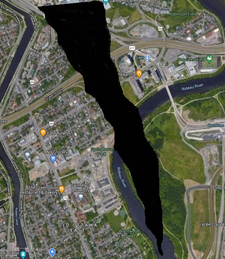
Image by Anthony Lenzo
For example, a Secondary Plan provides guidance on matters such as the limits on the height of buildings, on the type of housing allowed, and where commercial development should be encouraged.
But in the new draft Official Plan, City planners have unilaterally discarded OOE’s 2011 Secondary Plan, and have instead divided our community in two. The area north of Highway 417, and the area east of Brunswick Street would now be included in the downtown area for planning purposes.
Included in this northern area of OOE are the King’s Landing development, Greenfield Village, and the streets north of Highway 417, as well as Springhurst Park, the Lees Avenue apartments, and the open space between them, part of which is still earmarked for the Alta Vista Transportation Corridor (AVTC).
Under the draft Official Plan these areas would now be covered by a new Secondary Plan being prepared for an area mostly on the western side of the Rideau Canal to be known as the Central and East Downtown Core. They would be subject to the same planning guidelines as are applied, for example, to the area between Elgin Street and the Rideau Canal known as the Golden Triangle.
Many OOE residents have been concerned that policies included in the existing (2011) Secondary Plan would not be reflected in the new Secondary Plans covering our community. When asked if this would be the case, Miguelez stated “No, the approved policies are carried over into the new Secondary Plans”.
OOE now “transected”
The second contentious proposal, also a component of the new Official Plan, would split OOE into separate planning areas called “transects”. While a Secondary Plan covers a defined community, a transect covers a range of communities. Consider transects as layers of an onion.The outermost transect is called Rural, the next layer is called Suburban, and subsequent layers are called Outer Urban, Inner Urban, with the last or inner transect called the Downtown Core.
Old Ottawa East has been split between two of the transects, the Downtown Core and the Inner Urban transects. Again, those parts of our community north of Highway 417 and east of Brunswick Street will be included
When asked if the two parts of Old Ottawa East would be treated differently under the two separate transects, Miguelez replied “Yes, the transects defined in the new Official Plan propose to establish overall policy directions that are better tailored to different areas’ location within the city.”
The final planning rupture to our community comes with the decision to create a Special District for the Rideau Canal UNESCO World Heritage site. All of the houses currently on Echo Drive will be included in that Special District. If the creation of this Special District meant that new development along Echo Drive had to respect the historic context of the Rideau Canal, that would be a positive move. However, houses along Echo Drive may be subject to planning criteria separate and distinct from criteria applied to houses on neighbouring streets. When asked about this, Miguelez, confirmed that “they may, in time, [differ] as special district policies get further developed”.
An additional decision that will significantly affect the way planning is undertaken for Old Ottawa East was made a few years ago with the approval of Transit Oriented Development areas (TODs) for which special rules allow for greater development near transit stations, including the Lees transit station.
In the end, these changes will only affect planning documents. They neither change the actual geography or territory of Old Ottawa East nor the pride we feel for our community. What they will change, however, is the nature of this community. With so many parts of Old Ottawa East being subjected in future to different planning policies, for example, on maximum building heights, the relative homogeneity of our community will change. Moreover, if a planning document includes a number of communities, the ability of anyone community to influence the drafting of that document is diminished.
One implication of these changes is that the community will lose some degree of control over the development of Springhurst Park and the lands designated for the AVTC since they will be covered under separate planning documents from those covering the bulk of OOE. Planning for the development of Greenfield Avenue and the streets north of Highway 417 will be similarly affected. “Springhurst Park is such an important part of our community, and residents have invested so much time and effort in its development, that we, as a community, must do all we can to retain control over its evolution,” said Ania Kolodziej, a resident of Chestnut Street.
Oh, and one more thing. Citizens are requested to forget the term “intensification”. From now on, we are asked to think of adding more housing units as “regeneration”.
![]() The draft Official Plan for Ottawa can be found at Engage Ottawa: https://engage.ottawa.ca/the-new-official-plan, and residents can make comments until February 17th. Once approved by the City and the Province, the Official Plan cannot be appealed. The views of individual residents are critically important now and letters to the City and to City Councillors are influential.
The draft Official Plan for Ottawa can be found at Engage Ottawa: https://engage.ottawa.ca/the-new-official-plan, and residents can make comments until February 17th. Once approved by the City and the Province, the Official Plan cannot be appealed. The views of individual residents are critically important now and letters to the City and to City Councillors are influential.