John Dance
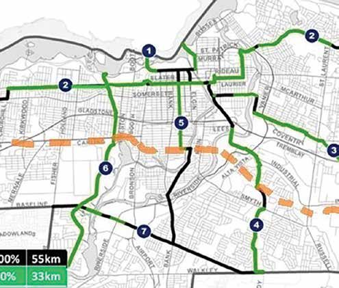
The dashed line approximates the location of a proposed east-west crosstown cycling route through Old Ottawa East and the Glebe. Current City plans would require local cyclists to pedal to either Laurier Avenue or Baseline/Heron/Walkley to access a major east-west cross-town route.
Image Base On City of Ottawa Map
An east-west cross-town cycling route going through Old Ottawa East should be included in the City’s new active transportation network, the Old Ottawa East Community Association (OOECA) says.
In order to bike any significant distance east or west, the draft plans of the City now would require local cyclists to either pedal downtown to access the cross-town cycling route that has Laurier Avenue at its centre or travel far to the south to the Baseline/Heron/ Walkley cross-town route. Both options would add considerable time to a cyclist’s trip and neither would be as safe or pleasant as a route through the Glebe and Old Ottawa East.
“The excellent investment in the Flora Footbridge – which we advocated for decades before it was finally built – would be a key component of a midtown eastwest cross-town cycling route,” Tom Scott, OOECA’s transportation and infrastructure director, recently wrote to Vivi Chi, the City’s senior officer responsible for the new Transportation Master Plan and its active transportation network.
“With the construction of a relatively less costly footbridge across the Rideau River at the eastern end of Clegg Street or somewhere farther south, cyclists and pedestrians could readily get to the eastern side of the river and beyond,” Scott noted.
“This cross-town route could then link up with the Hospital Link multi-use pathway, the hydro corridor or the new multi-use pathway of the Confederation Line that we’ve heard will go eastward right to Trim Road, “ Scott continued. “To the west, the midtown east-west cross-town route could incorporate the proposed cycling lanes along Carling Avenue.”
OOECA has asked that the City conduct a feasibility study of the new river footbridge that would be part of the proposed crosstown cycling route. A feasibility study was the first step that the City took when it considered building the Flora Footbridge and, through the related consultation and analysis, the bridge was justified and the optimal location was chosen.
Earlier in consultations on the new active transportation network, City staff told the community association that, while a new river footbridge will likely be built someday, it won’t be within the next 10 years and the driving force behind its creation will be the private sector’s development of the Hurdman area on the east side of the river, consistent with the City’s Hurdman “transit-oriented development” plans.
“This response fails to recognize the lack of safe accessibility from one side of the Rideau River to the other in the 2.5 kilometre stretch between the LRT bridge and Billings Bridge,” Scott noted. ”The McIlraith (Smyth) Bridge is within this stretch but, despite now having good cycling lanes, leads to a hazardous crossing of vehicles turning right down to Riverside and then to the hopelessly dangerous underpass of the rail lines so that Smyth is a poor way for cyclists to proceed east-west,” Scott added.
“I will review these two projects with the AT master planning team,” Chi responded to Scott. “Strong community support, such as that of the OOECA’s, has allowed the City to expand the cycling and pedestrian network significantly over the last decade. We endeavour to do more, as funding permits.”
In his letter, Scott reiterated OOECA’s steadfast opposition to the Alta Vista Transportation Corridor remaining in the Transportation Master Plan.
“[W]e remain dismayed to see that building of a roadway in the Alta Vista Transportation Corridor remains under active consideration in the TMP,” said Scott. “It never made much sense and now, with an announced Climate Change Emergency, a renewed stress on “Big Moves” of the Official Plan for active transportation, and the ongoing massive investment in LRT, it makes no sense at all.”