Back in 2020, Laura McLeod and Julie Harris of Heritage Ottawa conducted extensive research on the historical roots of Old Ottawa East (OOE) which they used to conduct a half-day walking tour of the community. The tour proved popular with those fortunate OOE residents who accompanied the researchers on the fact-filled walk around our neighbourhoods. In the following pages, The Mainstreeter reprints a shortened version of the walking tour relying on McLeod’s research notes and invites readers to stroll the community on a loop that begins and ends at the Children’s Garden
Laura McLeod & Mainstreeter Stafff
An Introduction to the Community
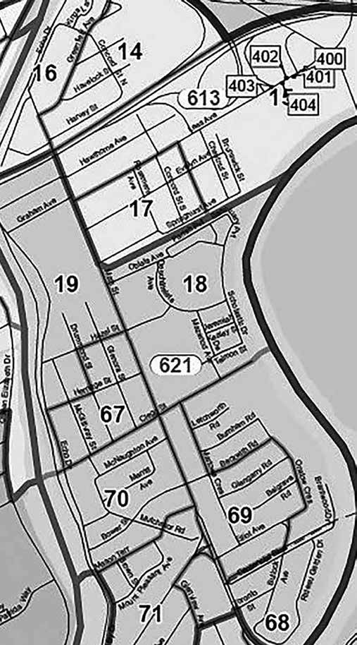
Before embarking on the walking tour, it’s helpful to review the boundaries of Old Ottawa East. The community’s primary east and west boundaries are the Rideau River and the Rideau Canal. The north boundary has fluctuated over time, and now includes the small triangle of land north of the Queensway and east of Colonel By Drive to Lees Avenue. The southern boundary is formed by the alignment of Riverside Drive and Main Street to the river. An interesting historical question mark is the southern boundary extension triangle of residential land formed by Avenue Road, Main Street and Riverdale Avenue. The land is mentioned in the official constitutions of both of the communities of Old Ottawa East and Old Ottawa South – and these days, residents enjoy both The Mainstreeter and the OSCAR community newspapers!
The entire community of Old Ottawa East is bound together by Main Street today, but historically, it had four distinct parts – Archville, Spenceville, Riverdale and Rideau Gardens. This historic walking trip will be focused on the Archville and Spenceville neighbourhoods. The northern part (Archville, 1873) extended from the Rideau Canal to Harvey Street and was predominantly settled by workers for the railway and building trades. The Village of Spenceville (1868) to the south extended from Hazel Street to Clegg Street along the Canal.
The largest institutional property is Saint Paul University, which was part of a larger assembly of land owned by the Oblates of St. Mary Immaculate. There are several other Catholic properties in the neighbourhood, as well as the old campus of Algonquin College that is largely hidden from view but visible from the Queensway and now forms the Lees Avenue campus of the University of Ottawa. Old Ottawa East has two parks, Brantwood and Springhurst, as well as linear green spaces along the river and the Canal. A new park is planned in the forecourt of the Deschâtelets Building off of Main Street. The main schools are Immaculata High School, Lady Evelyn Alternative School and Au Coeur d’Ottawa.
According to the 2021 Census, 8,580 people live in Old Ottawa East, but the number is growing with the development of the former Oblates property and the planning of Main Street as a true ‘main street’ with mixed-use development and commercial frontages. The community centre is the Old Town Hall, built in 1895 by architect Henry Ballantyne, and soon to be replaced by a new community centre currently under construction within the Deschâtelets Building. And, of course, one of the hubs of Old Ottawa East is The Green Door restaurant, which has been in operation since 1988.
With that background in mind, we begin our historic stroll at the Children’s Garden at the corner of Main and Clegg streets.
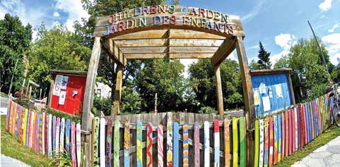
The Children’s Garden
The idea to establish a dedicated children’s garden was inspired by the High Park Children’s Garden in Toronto, and with the involvement of a number of community volunteers and partner organizations, Ottawa’s first dedicated children’s garden came into being in 2008. The space that the garden occupies was an underutilized park, named after Robert F. Legget, founding President of the Canadian Academy of Engineering and director of the National Research Council of Canada’s Division of Building Research.
After he retired, Dr. Legget wrote many books on the history of transportation in Canada including Ottawa Waterway: Gateway to A Continent, Rideau Waterway, Canals of Canada, and The Seaway, so it’s fitting that the park named in his honour is situated between the Rideau River and the Rideau Canal.
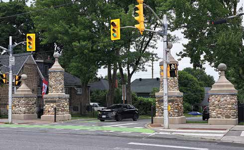
Leaving the Children’s Garden, we now head south along Main Street to the stone gates on Main Street and Beckwith Road, which most residents call the Brantwood Gates.
The Brantwood Gates
The expansion of Ottawa through annexation had one goal – to increase development and make it possible to improve the City. Each annexation was accompanied by residential development; industrial development of the City occurred principally through annexation. The agricultural and estate lands of Old Ottawa East, with large properties owned by the Ballantyne, Bower, Paterson and other prosperous and established families, were considered ripe for subdivision and development.
Following annexation of Old Ottawa East, Robert Sibbitt and Nepean Realty purchased most of the land on either side of Main Street, praying (unsuccessfully) that a streetcar line would be extended from Elgin Street across a never-built fixed bridge across the Canal where the Pretoria Bridge, which opens and cannot sustain a streetcar line, was constructed, and a second bridge across the Canal joining Fifth Avenue in the Glebe with what became Clegg Street. Sibbitt’s visionary residential subdivision was registered in late 1913. To promote his development, which he called Brantwood Place, he built grand river-stone gates on Main Street.
The lack of bridges, flooding along the Rideau River, and competition from other developments in the fast-growing City of Ottawa caught up with Sibbitt. By 1922, only a handful of houses had been built, including three houses to the north of the gates.
The gates were poorly built but they were well-loved by the community. In the 1940s, the City planned to demolish the gates, but the community rallied to have them repaired, rebuilt and dedicated as memorial gates. In 1949, the stone gates were dedicated “to the memory of those who made the supreme sacrifice and to the honour and glory of those men and women of this
community who served in the armed forces, 1914-1918/1939-1945.”
Brantwood Park
Down the hill from the Brantwood Gates we head towards the Rideau River. An important recreational space in the community is Brantwood Park. The park now includes tennis and pickle ball courts, a baseball diamond, play structures, a launch area for canoes and kayaks, and a skating rink in the winter. While swimming at the park now primarily takes place in the form of kids splashing in the City-run wading pool, the park used to boast a sandy beach along the Rideau River, making it a very popular watering hole. The park’s popularity grew following the Second World War, as Brantwood Park, along with nearby Windsor Park in Old Ottawa South were part of the City’s 5-year plan to improve its parks, an effort that started in 1948. Many Ottawans recall spending languid summer days bathing and sunning at Brantwood Beach.
History 101 – Rounded Doors
We amble back up the hill and through the Brantwood Gates to cross Main Street and head west along Bower Street, where we begin to notice a number of brick residences with unusual round-top front doors. Local researcher Christopher Ryan has investigated the history of the round-headed doors that you will see in this area south of Clegg Street and west of Main Street in Old Ottawa East.
Many of the houses in this area were built by developer Rupert McClelland between 1939 and 1949, during the Second World War and immediately afterwards. McClelland had built other homes and duplexes in other parts of the City, often using round-headed doors for the main entrance. Like the houses that we are seeing here below, his projects were normally wood-framed houses with brick cladding.
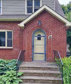
An example of the round doorways typical of Rupert McClellands’s design
Until 1939, however, McClelland’s construction projects were limited to a handful of houses. In 1942, he purchased a large property known as the Whitcomb property from the Public School Board. He laid out a subdivision in a typical City Beautiful pattern – Bower Street, Mason Terrace (named after McClelland’s brother Mason), Mount Pleasant Avenue and Mutchmor Road.
McClelland advertised the bungalows and two-storey homes for sale for $5,000-$7,000. The round-headed doors, as well as all the woodwork inside the houses framing the doors and windows, were built at his own factory on land that is now Tunney’s Pasture. The factory burned in 1949 as part of a large fire that destroyed many lumberyards in the area and, with it, the production of round-headed doors and accompanying door frames.
17 Mason Terrace
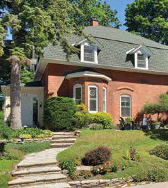
From Bower we turn left at Mutchmor Road for one block and then turn right onto Mason Terrace, heading toward Echo Drive and the Canal. Two houses in from Echo sits 17 Mason Terrace, a red brick house with yellow garage and vestibule. This house is the third oldest in the neighbourhood. Only the houses one block north at 3 Bower Street and 2 blocks north at 555 Mutchmor Road are older.
17 Mason Terrace was built in 1891 by the George W. Paterson family. The last family members to own the house – sisters Yule and Anna Paterson – sold it in 1971 to Ottawa architect Edward Cuhaci and his wife, Sylvia, who together built the house next door at 7 Mason Terrace on the west part of the property.
The house at 17 Mason Terrace are among the older in Old Ottawa East
Inside the house, 17 Mason Terrace has most of its original woodwork. It’s a solid brick house, which means that the window wells are very deep. The original building was two storeys with a hip or gable roof; it was converted into a false mansard roof some time after 1922. In 1971, an exterior vestibule was added, and the front door of the house was re-oriented to face Mason Terrace. Prior to this the main door faced towards Echo Drive and the Rideau Canal.
The house sits on top of a hillock created from fill excavated for the Rideau Canal in the 1820s.
One of the elements that connects this house to the Old Ottawa East neighbourhood is a former arched window that was said to have been the inspiration for McClelland’s rounded doorways that are found through the McClelland development of about 300 homes, described above, some of which we passed on our walk already.
The Cuhaci home at 7 Mason Terrace is a great example of modern architecture. Designed and built by Cuhaci in 1973, it remains the couple’s residence to this day. Capitalizing on perhaps one of the best views of the Rideau Canal, the home was designed as three off-set cubes with floor-to-ceiling windows to flood the interior with light.
From here we head around the corner walking north on Echo Drive and turn left a block later at Bower Street.
The Bower House – 3 Bower Street
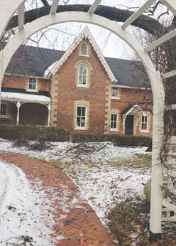
This enchanting house was built between 1865 and 1867. It is the oldest building in the area.
The house at 3 Bower Street are among the older in Old Ottawa East
The house was built by businessman-entrepreneur John Conrad Bower, a farmer, councillor and postmaster who also had a sawmill and general store in Osgoode. The property originally extended from the “Canal Road” along the Rideau Canal (just below Echo Drive) to Main Street and was later sub-divided for residential development during the early 1920s. The house was passed on to Bower’s son, dentist Ira Bower, who died in 1911. John Conrad had willed half of the property to his daughter, Sarah Bower, and the other half to Ira Bower. The father felt that he had already given enough to his third child at the time of that son’s marriage.
The house is one of Ottawa’s best and most intact examples of dichromatic Victorian brick architecture. It retains its steep gothic appearance with bargeboards and sits on a lovely and arresting piece of property nearby the Canal, next to another historically important property, the Harry Hodder House on the corner of Bower and Echo.
Harry Hodder House
This home, built in 1968, was one of Hart Massey’s last projects before he closed his internationally acclaimed architecture firm. This home is not only notable as a great example of mid-century modern architecture with Japanese influence (he had a large Japanese art collection), with three separate buildings with pyramidal roofs connected by a central entranceway, but also because of its notable residents. The first owner, Harry Hodder, lived here on his own. He is a former Deputy Chief Statistician of Canada. Barney Danson, former Minister of Defence resided here, as well as a certain Little Guy from Shawinigan. Yes, former Prime Minister Jean Chretien and his recently passed wife, Aline, lived here for 11 years.
History 101 – Early Land Division and Rideau Canal Value
Land values of real estate fronting the Rideau Canal have never been higher as older homes are being sold, demolished and replaced by modern homes
Here, we take a moment to reflect on the profound impact of the Rideau Canal on land use in the community. During and following the construction of the Canal, workers essentially squatted on the ordnance land bordering the waterway, but this practice was brought into order when registered plans for subdividing the land came into effect. Around this same time, financial pressures resulted in absentee speculators selling off their granted land, opening the area up for more development.
The area remained a rural neighbourhood, primarily populated by farmers and labourers. However, in the coming years, more people would come to the area, as a result of the land boom generated by the expanding lumber trade and the growing civil service. During this time, more plans for subdivision were registered in the area, with landowners looking to capitalize on the increased value of their large holdings. As the community grew through the next century, the process of subdividing the agricultural land in what is now Old Ottawa East continued well into the 1950s.
We can see more recent examples of continued development through infill and increased densification at a few properties along Echo Drive, where the larger older homes set further back from the canal have split the lots to allow more modern homes to be built on the now highly valuable land closer to the canal.
The Rideau Canal has played an important role in the development of Old Ottawa East, from early temporary settlements along its banks by Canal workers, to the use of the waterway to transport goods, to its current state as a well-used linear parkway that connects the neighbourhood to downtown Ottawa.
555 Echo Drive
The second oldest house in the community was built in 1874 with an addition in 1910 and an extension in 2007. Restoration of the exterior of the house won a heritage award in 2014. Old coats of exterior paint were removed, and the brickwork was restored. The front door arch was reconstructed, and the garden was restored to former glory.
555 Echo Drive was said to have been built by John Conrad Bower, who resided in the adjoining property at 3 Bower Street, for his daughter, Sarah Bower, as a way of trying to ensure her continued residence in the village of Ottawa East.
Clegg Street and Echo Drive
One block further north, where Echo Drive meets Clegg Street, the majestic new Flora Footbridge slices across the Canal joining Old Ottawa East and the Glebe. Lesser known but important to the history of the neighbourhood is another footbridge that allowed residents of both communities to cross the Canal.
From the early 1900s (likely, sometime after 1907 when Old Ottawa East was amalgamated into the City of Ottawa) right up to the 1960s, residents could take advantage of a wooden trestle footbridge that crossed the Canal from Herridge Avenue in Old Ottawa East to Second Avenue in the Glebe. The footbridge was only in place during winter when it was stabilized on the ice. Students could use the winter bridge to make a quicker journey across the Canal to get to Glebe Collegiate, the public high school or to Immaculata, the Catholic high school. For some years, during this period, some residents also took advantage of a private rowing service across the Canal run by a woman from Old Ottawa East.
We head next along Clegg Street towards Main Street and pass by Drummond and Glenora streets – with some interesting sights to see.
Glenora and Drummond Streets – Noffke Homes & Co-Housing
Werner Ernst Noffke was born in Stolp, Germany on April 9th, 1877. His family left Germany in 1884 along with 84 other Germans, all of whom headed to Ottawa, where Noffke’s family settled on 25 Third Street (now Montcalm Street).
In Old Ottawa East, Noffke designed and built the home at 182 Glenora Street – it is worth a look. Noffke designed this house in 1933 for his nephew Richard. Noffke’s many other Ottawa buildings include the Old Ottawa South Firehall on Sunnyside Avenue, the Champagne Bath on King Edward Street, the Medical Arts Building on Metcalfe Street, and numerous residential buildings, many of them in the Glebe.
Noffke never received formal training in architecture, instead learning his trade on the job and in night classes. In fact, during Noffke’s time, there existed no formal structured training program for architects anywhere in Canada. He trained through an applied apprenticeship. He was among the most prominent and prolific of Ottawa architects in the early to mid 20th century, in part because he had one of the longest careers, from his training period in the 1890s to his retirement in 1961. He died in 1964.
182 Glenora Street is an example of the Spanish Colonial Revival style favoured by famed architect W.E. Noffke.
Noffke was drawn to the Spanish Colonial Revival style of architecture and used it very frequently on some of the residential buildings he was commissioned to build, including the home at 182 Glenora. Early in his career, Noffke took a trip to California where he fell in love with this Mediterranean style. Noffke was drawn to the charm and romance associated with the style, characterized by stark stucco exterior walls, semi-enclosed porches and warm red or orange tiled roofing.
Throughout this walk, you will see several examples of infill housing. One that you don’t want to miss is located further north on Drummond Street and is an example of an environmental and social basis to living. Terra Firma is a small co-housing project that was started in 1997, when the founders bought and subsequently renovated two three-door townhouses. The community has since built an infill between the two buildings which houses a seventh residential unit and common space. The 12 families that currently live at Terra Firma engage in communal activities such as two shared meals a week and provide other forms of support for their community members.
On our way along Clegg Street to return to our starting point at the Children’s Garden at Main Street, stop for a moment at Glenora Street, and consider life in the village of Ottawa East on this corner back in 1888.
History 101 – Old Ottawa East 1888 to 1907
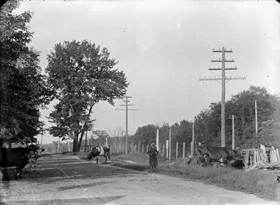
This photo taken in 1900 of a pedestrian walking along Fifth Street in Ottawa East (now Harvey Street) clearly shows that grazing cows were a common sight in many areas of the village before Annexations with the City of Ottawa in 1907.
What was life like here in Old Ottawa East back in 1888 before the village was annexed as part of the City of Ottawa? For starters, there was a strong political movement in 1888, when prominent community members petitioned the provincial government to incorporate Ottawa East as a village and to avoid annexation with the City of Ottawa. However, the pressure for annexation from the City in 1907 overcame the desire of the villagers to remain distinct. An offer from the City to freeze tax rates meant that there was less opposition and the community finally relented to annexation in 1907, when Ottawa East officially became part of the City of Ottawa.
With annexation, the village of Ottawa East ceased to exist, but the change had little immediate effect on the the daily lives of its residents. One change dating to the time of annexation that we still see today is the Glenora Street sign. Pre-annexation, Glenora was known as Bronson Street but this and other streets in the neighbourhood had to change names to avoid confusion with streets with the same name in the larger City of Ottawa.
In terms of the people who lived here at the time, Ottawa East had a modest population of 1,800, and featured amenities including two schools, a town hall, sidewalks, and a relatively recent water system. The community was blue-collar, with most residents employed by the railways, brickyards, and lumber industry. Directories from the time show us that many of the residents near the corner of Glenora and Clegg, where the houses date to around 1906/1907, were general labourers, watchmen, and carpenters. The ethnic composition was made up from five main groups: French (Quebec), English, Irish, German and Scots.